Hidden Yield Killers: What Subsurface Drainage Condition Is Telling You About Field-Level Productivity
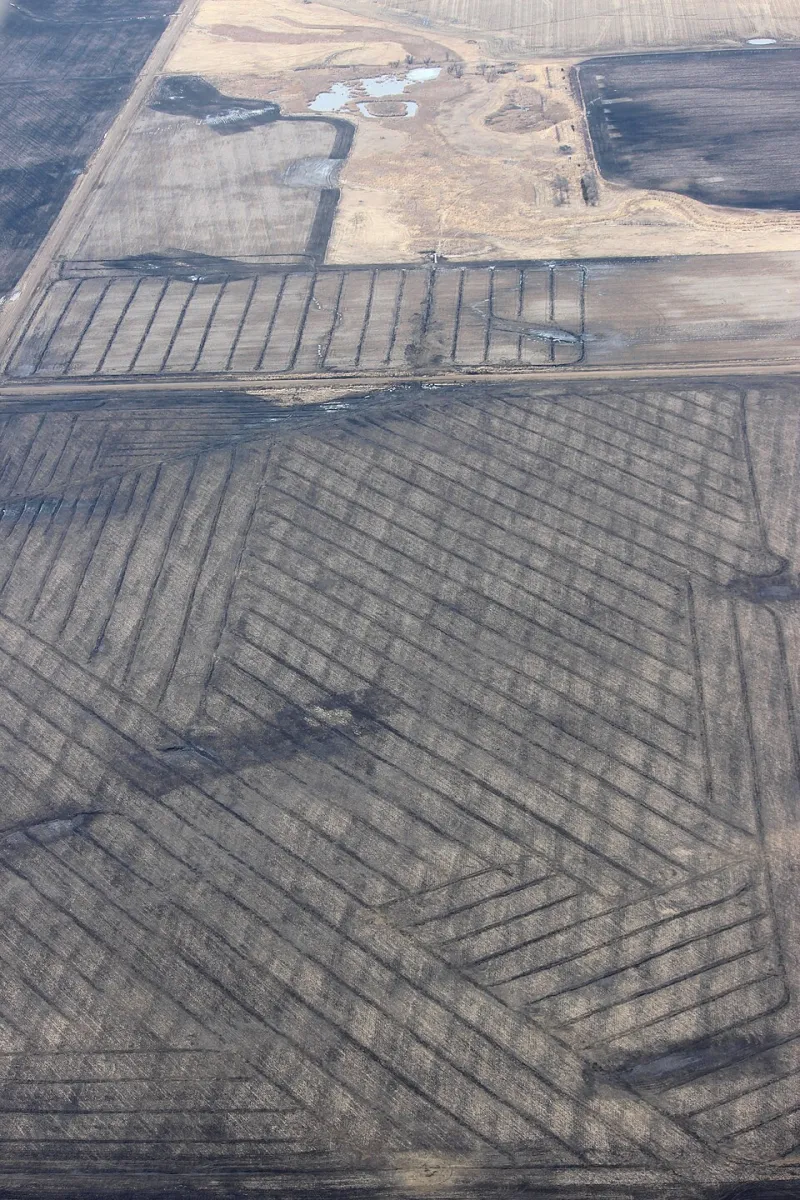
Photo: USFWS Mountain-Prairie, Public domain, via Wikimedia Commons
For decades, agricultural analysis has treated fields as relatively uniform units — a given number of acres assigned a single yield expectation based on soil type, historical performance, and seasonal weather. But within-field variability is increasingly demanding a more granular accounting. One of the most consequential and least-discussed drivers of that variability is subsurface drainage infrastructure: specifically, the age, density, and maintenance status of the tile systems running beneath the surface.
In wet springs — which have become more frequent across the Corn Belt and much of the Upper Midwest — the condition of a field's drainage network is not a peripheral concern. It is often the single most determinative factor in whether early-season stress translates into a full-season yield penalty or is absorbed without lasting consequence.
The Infrastructure Beneath the Numbers
Subsurface tile drainage in American agriculture spans an enormous range of vintages. Clay tile systems installed in the mid-twentieth century remain operational across portions of Iowa, Illinois, Indiana, and Ohio — some functioning adequately, others degraded by root intrusion, sediment accumulation, or structural collapse. Corrugated plastic tubing installed in the 1980s and 1990s represents a second generation of infrastructure, now reaching the age at which performance variability becomes pronounced. Newer, engineered systems with controlled drainage outlets and higher installation densities represent the current standard — but they are far from universal.
The result is a patchwork of drainage performance across the American agricultural landscape, and critically, within individual operations. A single producer may farm ground with three or four distinct drainage generations, each responding differently to the same rainfall event. When yield monitors aggregate that performance into field-level averages, the underperformance of compromised drainage zones is often masked — visible only in the spatial data patterns that precision agriculture tools are increasingly capable of revealing.
Wet Springs as a Diagnostic Event
From a forecasting standpoint, a wet spring is not merely a weather challenge — it is a diagnostic stress test for drainage infrastructure. Fields with dense, well-maintained tile networks shed excess moisture quickly, preserving soil structure and enabling timely planting. Fields operating on aging or partially failed systems hold water longer, compressing planting windows and creating conditions for compaction when equipment enters too early.
The downstream yield consequences are well-documented. Every day of planting delay past the agronomic optimum — typically early May for corn in the central Corn Belt — carries a measurable yield penalty. University extension research across Illinois and Iowa consistently places that penalty in the range of one to two bushels per acre per day for corn beyond late April, with the curve steepening after mid-May. For a producer farming 1,500 acres, a drainage-induced planting delay of five days across even a portion of that ground can represent a yield loss that dwarfs the annualized cost of a drainage upgrade.
Beyond delayed planting, inadequate drainage contributes to nitrogen loss through denitrification, reduced root development in saturated soil profiles, and increased disease pressure — particularly for soybeans, which are highly sensitive to prolonged saturation during early vegetative stages. These effects are cumulative and, in wet years, interact in ways that compound the initial planting-window penalty.
Quantifying the Drainage Yield Gap
Precise quantification of drainage-related yield gaps requires field-level data that most operations have not historically collected in a systematic way. However, yield monitor data, when analyzed spatially and correlated with drainage infrastructure maps, frequently reveals consistent low-yield zones that track tile system gaps or failure points rather than soil type boundaries.
Several land-grant university programs have undertaken controlled comparisons of tile spacing and drainage intensity, with results indicating that moving from 60-foot tile spacing to 40-foot spacing — a common upgrade pathway — can improve corn yields by 15 to 30 bushels per acre in years with above-normal spring precipitation. At current corn prices, that yield increment represents $60 to $120 per acre in gross revenue in a single season. The installed cost of a drainage upgrade, depending on system complexity and contractor pricing, typically ranges from $500 to $1,000 per acre — implying a payback period of five to ten years in favorable yield and price environments, and potentially less when financing costs and tax treatment are factored appropriately.
What that calculation often omits is the consistency premium. A field with high-performance drainage does not merely yield more in wet years — it yields more predictably across the full range of seasonal conditions, which has direct implications for both enterprise planning and lender relationships.
Drainage as a Forecasting Input
At Martell Crop Projections, the analytical value of drainage infrastructure data lies in its capacity to improve field-level yield forecasting before the growing season begins. When drainage condition is mapped alongside historical yield data and seasonal precipitation outlooks, it becomes possible to identify fields that are structurally exposed to downside risk in wet-spring scenarios — not because of soil quality, but because of infrastructure limitations that are entirely addressable.
This reframes drainage condition from a maintenance question to a forecasting variable. A producer entering a spring with a La Niña-influenced precipitation outlook and a portfolio of fields with aging tile systems faces a different risk profile than one with equivalent acreage and upgraded infrastructure. The difference is not captured in traditional soil productivity ratings or crop insurance actuarial tables — it is embedded in the physical condition of systems that rarely appear in any standard agronomic assessment.
For operations that have invested in precision data collection, spatial yield analysis correlated with drainage maps can identify specific zones where infrastructure investment would generate the highest marginal return. This is not a generalized recommendation to tile every acre — it is a targeted, data-driven prioritization of capital that treats drainage upgrades as yield investments rather than maintenance expenditures.
What to Do With This Information
Producers who have not recently assessed their tile system condition should consider commissioning a drainage survey — particularly on ground that shows persistent wet zones in aerial imagery, consistent low-yield areas in spatial yield maps, or a history of delayed spring fieldwork. Contractors with camera inspection capability can identify blockages, root intrusion, and structural failures that are not visible from the surface.
For those evaluating whether to invest in system upgrades or extensions, the analysis should be grounded in field-specific yield history rather than regional averages. A field that has underperformed its soil productivity rating by 10 to 15 bushels per acre in three of the last five seasons — particularly in years with above-normal spring precipitation — is a strong candidate for drainage-related underperformance.
The infrastructure beneath the topsoil is not glamorous. It does not appear on satellite imagery, it is not reflected in seed company trial data, and it rarely surfaces in market analysis. But for field-level yield forecasting, it may be among the most consequential variables that remains systematically underweighted — and for producers willing to treat it as intelligence rather than overhead, the competitive advantage is both measurable and durable.